The Ohio Hopewell Culture

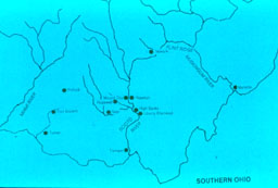
Map of the Hopewell cultural area in southern Ohio.


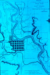
Map of twelve miles of the Central Scioto River Valley. Ephraim Squier and Edwin Davis, 1848. This engraving is from the first volume published by the Smithsonian Institution. As both a literary and archaeological document, it records the beginnings of scientific study of the many hundreds of earthworks found between the Appalachians and the Great Plains. While the map is generally accurate, there are a few typographic changes in mound locations and enclosure shapes which differ from those on the copies of two working maps now curated by the Library of Congress.


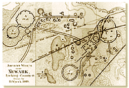
Map of Newark Earthworks. Charles Whittlesey, Ephraim Squier and Edwin Davis, 1848. Located near the present day city of Newark at the confluence of two tributaries of the Licking River, this is one of the largest and more complex enclosures. Relatively few geometric enclosures occur in the Licking Muskingum valley, which runs through unglaciated lands, and is less broad, for example, than the Miami or Scioto valleys. However, there are other Hopewell sites nearby including Flint Ridge, a major Hopewell chalcedony source and Murphy, an open site. The Marietta Earthworks, the first set of enclosures reported to the eastern antiquarians in the 1790s, is at the end of the valley where the Muskingum joins the Ohio River.


Forward to the next page of this essay

Back to the previous page

Back to Online Essays


   Department of Anthropology
   copyright © 2002 University of Illinois, All rights reserved.
Questions and Comments to Brenda Farnell