|
“A
Century
of Progress”: The Portrayal of Indians in American
History Textbooks (cont.)
|
Besides an interpretive framework that may be less than satisfying,
many recently published textbooks possess other problems as well.
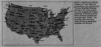
For example, many textbook authors and publishers include
maps indicating the location of Native tribes at the time of
European contact. There is nothing inherently wrong with this,
but the maps can often be misleading. The map at right, for
instance, notes the location of the Seminoles in Florida at
the time of European contact even though the Seminoles did
not exist as a distinct group until the late 1700s. Nor did
the Crows or the Navajos. |
|
|
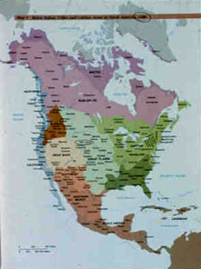
This
map is somewhat better—or
at least more colorful—but
it too has problems. Though difficult to make out in this
small image, it describes the Sioux as being primarily
west of the
Mississippi 200 years before they actually entered the region.
But occasional
errors are less significant than the difficulties inherent
in mapping Native America. Like people throughout
the world, American Indian groups did not remain stationary.
The cultural landscape of the Americas changed and evolved
over time—though one could not tell this from most
textbook maps. This failure fosters the idea of Native people
being somehow rooted in particular places and tied to the
land in ways that other groups are not. In a subtle way that
most students would rarely consider a problem, these maps
make American Indian groups appear to be static and unchanging
|
For more on the topic of mapping Native America, follow this link.
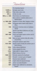
Mapping
chronologies poses challenges no less difficult that mapping
geography. Look at this timeline
from a well-respected
textbook. Note the discrepancies in scale between the “prehistoric” and
the “historic” periods. What are the implications
of this irregular telescoping of time? |
|
Continue with this Online Essay
Back to the Previous Page |